| at: |
Holly Springs National Forest - North |
Data from USFS GIS
 show on map
 animate
Trail users:


Elevation Profile
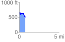
 0.748483 mi
 154.61 ft
 253.78 ft
 -99.18 ft
 6.42 %
GPX Downloads: Track Route
![]()
| at: |
Holly Springs National Forest - North |
show on map
animate
0.748483 mi
154.61 ft
253.78 ft
-99.18 ft
6.42 %