|
| at: |
Holly Springs National Forest - North |
Data from USFS GIS
 show on map
 animate
Trail users:


Elevation Profile
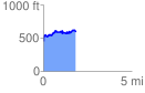
 1.813802 mi
 367.63 ft
 231.86 ft
 135.76 ft
 3.84 %
GPX Downloads: Track Route
![]()
|
| at: |
Holly Springs National Forest - North |
show on map
animate
1.813802 mi
367.63 ft
231.86 ft
135.76 ft
3.84 %