| at: |
Holly Springs National Forest - North |
Data from USFS GIS
 show on map
 animate
Trail users:


Elevation Profile
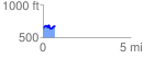
 0.694851 mi
 146.08 ft
 114.30 ft
 31.77 ft
 3.98 %
GPX Downloads: Track Route
![]()
| at: |
Holly Springs National Forest - North |
show on map
animate
0.694851 mi
146.08 ft
114.30 ft
31.77 ft
3.98 %