| at: |
Holly Springs National Forest - North |
Data from USFS GIS
 show on map
 animate
Trail users:


Elevation Profile
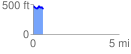
 0.573863 mi
 77.91 ft
 103.34 ft
 -25.43 ft
 3.41 %
GPX Downloads: Track Route
![]()
| at: |
Holly Springs National Forest - North |
show on map
animate
0.573863 mi
77.91 ft
103.34 ft
-25.43 ft
3.41 %