|
| at: |
Holly Springs National Forest - North |
Data from USFS GIS
 show on map
 animate
Trail users:


Elevation Profile
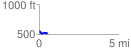
 0.508524 mi
 45.36 ft
 80.46 ft
 -35.10 ft
 3.00 %
GPX Downloads: Track Route
![]()
|
| at: |
Holly Springs National Forest - North |
show on map
animate
0.508524 mi
45.36 ft
80.46 ft
-35.10 ft
3.00 %