| at: |
Holly Springs National Forest - North |
Data from USFS GIS
 show on map
 animate
Trail users:


Elevation Profile
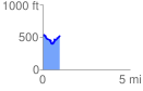
 0.999659 mi
 182.14 ft
 189.93 ft
 -7.79 ft
 3.60 %
GPX Downloads: Track Route
![]()
| at: |
Holly Springs National Forest - North |
show on map
animate
0.999659 mi
182.14 ft
189.93 ft
-7.79 ft
3.60 %