|
| at: |
Holly Springs National Forest - North |
Data from USFS GIS
 show on map
 animate
Trail users:


Elevation Profile
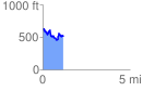
 1.191650 mi
 232.51 ft
 325.80 ft
 -93.28 ft
 5.18 %
GPX Downloads: Track Route
![]()
|
| at: |
Holly Springs National Forest - North |
show on map
animate
1.191650 mi
232.51 ft
325.80 ft
-93.28 ft
5.18 %