| at: |
Holly Springs National Forest - North |
Data from USFS GIS
 show on map
 animate
Trail users:


Elevation Profile
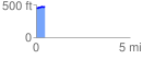
 0.481726 mi
 32.01 ft
 18.13 ft
 13.88 ft
 1.26 %
GPX Downloads: Track Route
![]()
| at: |
Holly Springs National Forest - North |
show on map
animate
0.481726 mi
32.01 ft
18.13 ft
13.88 ft
1.26 %