|
| at: |
Delta National Forest |
Data from USFS GIS
 show on map
 animate
Trail users:


Elevation Profile
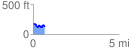
 0.692336 mi
 75.35 ft
 106.13 ft
 -30.78 ft
 2.90 %
GPX Downloads: Track Route
![]()
|
| at: |
Delta National Forest |
show on map
animate
0.692336 mi
75.35 ft
106.13 ft
-30.78 ft
2.90 %