|
| at: |
Delta National Forest |
Data from USFS GIS
 show on map
 animate
Trail users:


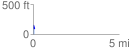
Elevation Profile
 0.088083 mi
 14.64 ft
 52.63 ft
 -37.98 ft
 11.32 %
GPX Downloads: Track Route
![]()
|
| at: |
Delta National Forest |
show on map
animate
0.088083 mi
14.64 ft
52.63 ft
-37.98 ft
11.32 %