|
| at: |
Delta National Forest |
Data from USFS GIS
 show on map
 animate
Trail users:


Elevation Profile
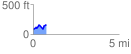
 0.752913 mi
 156.06 ft
 77.17 ft
 78.89 ft
 3.93 %
GPX Downloads: Track Route
![]()
|
| at: |
Delta National Forest |
show on map
animate
0.752913 mi
156.06 ft
77.17 ft
78.89 ft
3.93 %