|
| at: |
Bienville National Forest |
Data from USFS GIS
 show on map
 animate
Trail users:


Elevation Profile
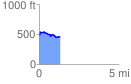
 1.309725 mi
 128.03 ft
 141.36 ft
 -13.32 ft
 2.04 %
GPX Downloads: Track Route
![]()
|
| at: |
Bienville National Forest |
show on map
animate
1.309725 mi
128.03 ft
141.36 ft
-13.32 ft
2.04 %