|
| at: |
Bienville National Forest |
Data from USFS GIS
 show on map
 animate
Trail users:


Elevation Profile
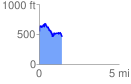
 1.439836 mi
 305.58 ft
 394.98 ft
 -89.41 ft
 5.20 %
GPX Downloads: Track Route
![]()
|
| at: |
Bienville National Forest |
show on map
animate
1.439836 mi
305.58 ft
394.98 ft
-89.41 ft
5.20 %