|
| at: |
Bienville National Forest |
Data from USFS GIS
 show on map
 animate
Trail users:


Elevation Profile
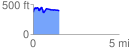
 1.528020 mi
 217.56 ft
 195.69 ft
 21.87 ft
 2.70 %
GPX Downloads: Track Route
![]()
|
| at: |
Bienville National Forest |
show on map
animate
1.528020 mi
217.56 ft
195.69 ft
21.87 ft
2.70 %