|
| at: |
Bienville National Forest |
Data from USFS GIS
 show on map
 animate
Trail users:


Elevation Profile
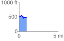
 0.986978 mi
 91.52 ft
 166.82 ft
 -75.30 ft
 3.20 %
GPX Downloads: Track Route
![]()
|
| at: |
Bienville National Forest |
show on map
animate
0.986978 mi
91.52 ft
166.82 ft
-75.30 ft
3.20 %