|
| at: |
Bienville National Forest |
Data from USFS GIS
 show on map
 animate
Trail users:


Elevation Profile
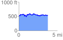
 3.778433 mi
 459.08 ft
 450.17 ft
 8.92 ft
 2.30 %
GPX Downloads: Track Route
![]()
|
| at: |
Bienville National Forest |
show on map
animate
3.778433 mi
459.08 ft
450.17 ft
8.92 ft
2.30 %