|
| at: |
Bienville National Forest |
Data from USFS GIS
 show on map
 animate
Trail users:


Elevation Profile
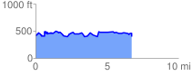
 6.804276 mi
 623.71 ft
 668.88 ft
 -45.17 ft
 1.86 %
GPX Downloads: Track Route
![]()
|
| at: |
Bienville National Forest |
show on map
animate
6.804276 mi
623.71 ft
668.88 ft
-45.17 ft
1.86 %