|
| at: |
Bienville National Forest |
Data from USFS GIS
 show on map
 animate
Trail users:


Elevation Profile
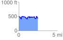
 2.456280 mi
 345.69 ft
 392.59 ft
 -46.90 ft
 3.03 %
GPX Downloads: Track Route
![]()
|
| at: |
Bienville National Forest |
show on map
animate
2.456280 mi
345.69 ft
392.59 ft
-46.90 ft
3.03 %