|
| at: |
Bienville National Forest |
Data from USFS GIS
 show on map
 animate
Trail users:


Elevation Profile
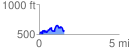
 1.569648 mi
 330.27 ft
 257.43 ft
 72.84 ft
 3.99 %
GPX Downloads: Track Route
![]()
|
| at: |
Bienville National Forest |
show on map
animate
1.569648 mi
330.27 ft
257.43 ft
72.84 ft
3.99 %