|
| at: |
Bienville National Forest |
Data from USFS GIS
 show on map
 animate
Trail users:


Elevation Profile
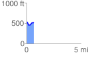
 0.669192 mi
 61.51 ft
 89.06 ft
 -27.55 ft
 2.52 %
GPX Downloads: Track Route
![]()
|
| at: |
Bienville National Forest |
show on map
animate
0.669192 mi
61.51 ft
89.06 ft
-27.55 ft
2.52 %