|
| at: |
Bienville National Forest |
Data from USFS GIS
 show on map
 animate
Trail users:


Elevation Profile
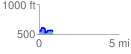
 0.854089 mi
 139.52 ft
 135.93 ft
 3.60 ft
 3.09 %
GPX Downloads: Track Route
![]()
|
| at: |
Bienville National Forest |
show on map
animate
0.854089 mi
139.52 ft
135.93 ft
3.60 ft
3.09 %