|
| at: |
Bienville National Forest |
Data from USFS GIS
 show on map
 animate
Trail users:


Elevation Profile
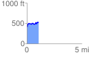
 1.086992 mi
 176.88 ft
 75.37 ft
 101.52 ft
 3.08 %
GPX Downloads: Track Route
![]()
|
| at: |
Bienville National Forest |
show on map
animate
1.086992 mi
176.88 ft
75.37 ft
101.52 ft
3.08 %