| at: |
Bienville National Forest |
Data from USFS GIS
 show on map
 animate
Trail users:


Elevation Profile
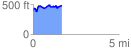
 1.671339 mi
 270.23 ft
 179.72 ft
 90.51 ft
 3.06 %
GPX Downloads: Track Route
![]()
| at: |
Bienville National Forest |
show on map
animate
1.671339 mi
270.23 ft
179.72 ft
90.51 ft
3.06 %