|
| at: |
Bienville National Forest |
Data from USFS GIS
 show on map
 animate
Trail users:


Elevation Profile
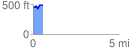
 0.573019 mi
 83.00 ft
 66.92 ft
 16.08 ft
 2.74 %
GPX Downloads: Track Route
![]()
|
| at: |
Bienville National Forest |
show on map
animate
0.573019 mi
83.00 ft
66.92 ft
16.08 ft
2.74 %