|
| at: |
Bienville National Forest |
Data from USFS GIS
 show on map
 animate
Trail users:


Elevation Profile
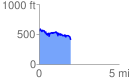
 1.997526 mi
 271.37 ft
 416.09 ft
 -144.72 ft
 3.95 %
GPX Downloads: Track Route
![]()
|
| at: |
Bienville National Forest |
show on map
animate
1.997526 mi
271.37 ft
416.09 ft
-144.72 ft
3.95 %