|
| at: |
Bienville National Forest |
Data from USFS GIS
 show on map
 animate
Trail users:


Elevation Profile
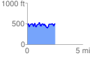
 2.580143 mi
 508.00 ft
 548.83 ft
 -40.83 ft
 4.03 %
GPX Downloads: Track Route
![]()
|
| at: |
Bienville National Forest |
show on map
animate
2.580143 mi
508.00 ft
548.83 ft
-40.83 ft
4.03 %