|
| at: |
Bienville National Forest |
Data from USFS GIS
 show on map
 animate
Trail users:


Elevation Profile
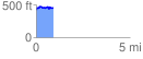
 0.920887 mi
 125.15 ft
 92.09 ft
 33.06 ft
 2.57 %
GPX Downloads: Track Route
![]()
|
| at: |
Bienville National Forest |
show on map
animate
0.920887 mi
125.15 ft
92.09 ft
33.06 ft
2.57 %