|
| at: |
Bienville National Forest |
Data from USFS GIS
 show on map
 animate
Trail users:


Elevation Profile
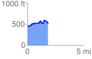
 1.834553 mi
 248.38 ft
 189.06 ft
 59.33 ft
 2.56 %
GPX Downloads: Track Route
![]()
|
| at: |
Bienville National Forest |
show on map
animate
1.834553 mi
248.38 ft
189.06 ft
59.33 ft
2.56 %