|
| at: |
Bienville National Forest |
Data from USFS GIS
 show on map
 animate
Trail users:


Elevation Profile
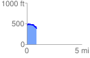
 0.885032 mi
 60.25 ft
 159.20 ft
 -98.95 ft
 3.41 %
GPX Downloads: Track Route
![]()
|
| at: |
Bienville National Forest |
show on map
animate
0.885032 mi
60.25 ft
159.20 ft
-98.95 ft
3.41 %