|
| at: |
Bienville National Forest |
Data from USFS GIS
 show on map
 animate
Trail users:


Elevation Profile
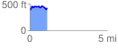
 1.102310 mi
 178.63 ft
 129.36 ft
 49.26 ft
 3.07 %
GPX Downloads: Track Route
![]()
|
| at: |
Bienville National Forest |
show on map
animate
1.102310 mi
178.63 ft
129.36 ft
49.26 ft
3.07 %