|
| at: |
Bienville National Forest |
Data from USFS GIS
 show on map
 animate
Trail users:


Elevation Profile
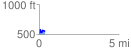
 0.368154 mi
 101.52 ft
 64.20 ft
 37.32 ft
 5.22 %
GPX Downloads: Track Route
![]()
|
| at: |
Bienville National Forest |
show on map
animate
0.368154 mi
101.52 ft
64.20 ft
37.32 ft
5.22 %