| at: |
Bienville National Forest |
Data from USFS GIS
 show on map
 animate
Trail users:


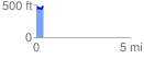
Elevation Profile
 0.380395 mi
 86.48 ft
 59.86 ft
 26.62 ft
 4.31 %
GPX Downloads: Track Route
![]()
| at: |
Bienville National Forest |
show on map
animate
0.380395 mi
86.48 ft
59.86 ft
26.62 ft
4.31 %