| at: |
Bienville National Forest |
Data from USFS GIS
 show on map
 animate
Trail users:


Elevation Profile
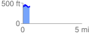
 0.591345 mi
 149.40 ft
 150.10 ft
 -0.70 ft
 4.81 %
GPX Downloads: Track Route
![]()
| at: |
Bienville National Forest |
show on map
animate
0.591345 mi
149.40 ft
150.10 ft
-0.70 ft
4.81 %