| at: |
Bienville National Forest |
Data from USFS GIS
 show on map
 animate
Trail users:


Elevation Profile
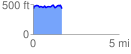
 1.688669 mi
 188.60 ft
 185.27 ft
 3.33 ft
 2.12 %
GPX Downloads: Track Route
![]()
| at: |
Bienville National Forest |
show on map
animate
1.688669 mi
188.60 ft
185.27 ft
3.33 ft
2.12 %