| at: |
Bienville National Forest |
Data from USFS GIS
 show on map
 animate
Trail users:


Elevation Profile
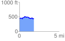
 1.832048 mi
 148.73 ft
 162.05 ft
 -13.33 ft
 1.68 %
GPX Downloads: Track Route
![]()
| at: |
Bienville National Forest |
show on map
animate
1.832048 mi
148.73 ft
162.05 ft
-13.33 ft
1.68 %