| at: |
Bienville National Forest |
Data from USFS GIS
 show on map
 animate
Trail users:


Elevation Profile
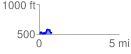
 0.798100 mi
 153.11 ft
 126.09 ft
 27.01 ft
 3.63 %
GPX Downloads: Track Route
![]()
| at: |
Bienville National Forest |
show on map
animate
0.798100 mi
153.11 ft
126.09 ft
27.01 ft
3.63 %