|
| at: |
Bienville National Forest |
Data from USFS GIS
 show on map
 animate
Trail users:


Elevation Profile
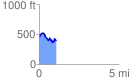
 1.057494 mi
 191.63 ft
 252.17 ft
 -60.54 ft
 4.52 %
GPX Downloads: Track Route
![]()
|
| at: |
Bienville National Forest |
show on map
animate
1.057494 mi
191.63 ft
252.17 ft
-60.54 ft
4.52 %