| at: |
Bienville National Forest |
Data from USFS GIS
 show on map
 animate
Trail users:


Elevation Profile
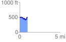
 0.963636 mi
 177.66 ft
 165.39 ft
 12.27 ft
 3.49 %
GPX Downloads: Track Route
![]()
| at: |
Bienville National Forest |
show on map
animate
0.963636 mi
177.66 ft
165.39 ft
12.27 ft
3.49 %