|
| at: |
Bienville National Forest |
Data from USFS GIS
 show on map
 animate
Trail users:


Elevation Profile
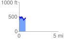
 0.847080 mi
 259.71 ft
 209.49 ft
 50.22 ft
 5.81 %
GPX Downloads: Track Route
![]()
|
| at: |
Bienville National Forest |
show on map
animate
0.847080 mi
259.71 ft
209.49 ft
50.22 ft
5.81 %