|
| at: |
Bienville National Forest |
Data from USFS GIS
 show on map
 animate
Trail users:


Elevation Profile
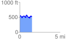
 1.522382 mi
 237.63 ft
 250.77 ft
 -13.13 ft
 3.12 %
GPX Downloads: Track Route
![]()
|
| at: |
Bienville National Forest |
show on map
animate
1.522382 mi
237.63 ft
250.77 ft
-13.13 ft
3.12 %