|
| at: |
Bienville National Forest |
Data from USFS GIS
 show on map
 animate
Trail users:


Elevation Profile
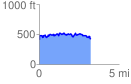
 3.232071 mi
 395.79 ft
 386.26 ft
 9.53 ft
 2.32 %
GPX Downloads: Track Route
![]()
|
| at: |
Bienville National Forest |
show on map
animate
3.232071 mi
395.79 ft
386.26 ft
9.53 ft
2.32 %