| at: |
Bienville National Forest |
Data from USFS GIS
 show on map
 animate
Trail users:


Elevation Profile
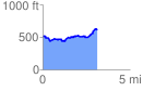
 3.140287 mi
 404.33 ft
 287.14 ft
 117.19 ft
 2.44 %
GPX Downloads: Track Route
![]()
| at: |
Bienville National Forest |
show on map
animate
3.140287 mi
404.33 ft
287.14 ft
117.19 ft
2.44 %