|
| at: |
Bienville National Forest |
Data from USFS GIS
 show on map
 animate
Trail users:


Elevation Profile
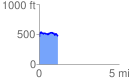
 1.151257 mi
 142.47 ft
 137.68 ft
 4.79 ft
 2.34 %
GPX Downloads: Track Route
![]()
|
| at: |
Bienville National Forest |
show on map
animate
1.151257 mi
142.47 ft
137.68 ft
4.79 ft
2.34 %