|
| at: |
Bienville National Forest |
Data from USFS GIS
 show on map
 animate
Trail users:


Elevation Profile
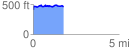
 1.768706 mi
 202.35 ft
 149.97 ft
 52.38 ft
 2.17 %
GPX Downloads: Track Route
![]()
|
| at: |
Bienville National Forest |
show on map
animate
1.768706 mi
202.35 ft
149.97 ft
52.38 ft
2.17 %