|
| at: |
Bienville National Forest |
Data from USFS GIS
 show on map
 animate
Trail users:


Elevation Profile
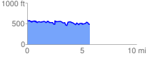
 5.778099 mi
 523.12 ft
 632.46 ft
 -109.34 ft
 2.07 %
GPX Downloads: Track Route
![]()
|
| at: |
Bienville National Forest |
show on map
animate
5.778099 mi
523.12 ft
632.46 ft
-109.34 ft
2.07 %