| at: |
Bienville National Forest |
Data from USFS GIS
 show on map
 animate
Trail users:


Elevation Profile
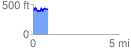
 0.869457 mi
 151.26 ft
 145.77 ft
 5.48 ft
 3.29 %
GPX Downloads: Track Route
![]()
| at: |
Bienville National Forest |
show on map
animate
0.869457 mi
151.26 ft
145.77 ft
5.48 ft
3.29 %