| at: |
Bienville National Forest |
Data from USFS GIS
 show on map
 animate
Trail users:


Elevation Profile
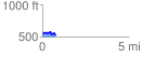
 0.772301 mi
 88.58 ft
 92.67 ft
 -4.10 ft
 2.27 %
GPX Downloads: Track Route
![]()
| at: |
Bienville National Forest |
show on map
animate
0.772301 mi
88.58 ft
92.67 ft
-4.10 ft
2.27 %