|
| at: |
Bienville National Forest |
Data from USFS GIS
 show on map
 animate
Trail users:


Elevation Profile
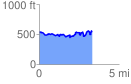
 3.326723 mi
 530.98 ft
 518.56 ft
 12.41 ft
 3.02 %
GPX Downloads: Track Route
![]()
|
| at: |
Bienville National Forest |
show on map
animate
3.326723 mi
530.98 ft
518.56 ft
12.41 ft
3.02 %