|
| at: |
Bienville National Forest |
Data from USFS GIS
 show on map
 animate
Trail users:


Elevation Profile
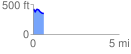
 0.604850 mi
 47.06 ft
 119.38 ft
 -72.32 ft
 3.74 %
GPX Downloads: Track Route
![]()
|
| at: |
Bienville National Forest |
show on map
animate
0.604850 mi
47.06 ft
119.38 ft
-72.32 ft
3.74 %