|
| at: |
Bienville National Forest |
Data from USFS GIS
 show on map
 animate
Trail users:


Elevation Profile
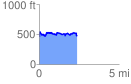
 2.393476 mi
 341.35 ft
 331.96 ft
 9.39 ft
 2.70 %
GPX Downloads: Track Route
![]()
|
| at: |
Bienville National Forest |
show on map
animate
2.393476 mi
341.35 ft
331.96 ft
9.39 ft
2.70 %